Thursday 27 April 2017

Bridge across the river Marlais at Llandybie.

A Grade II listed building. See British Listed Buildings.

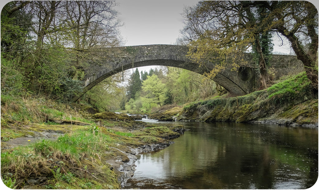
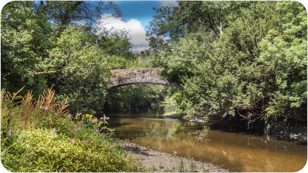
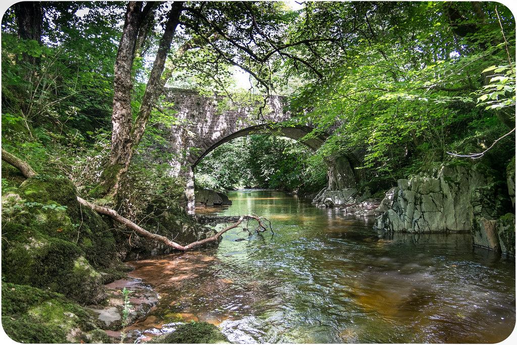
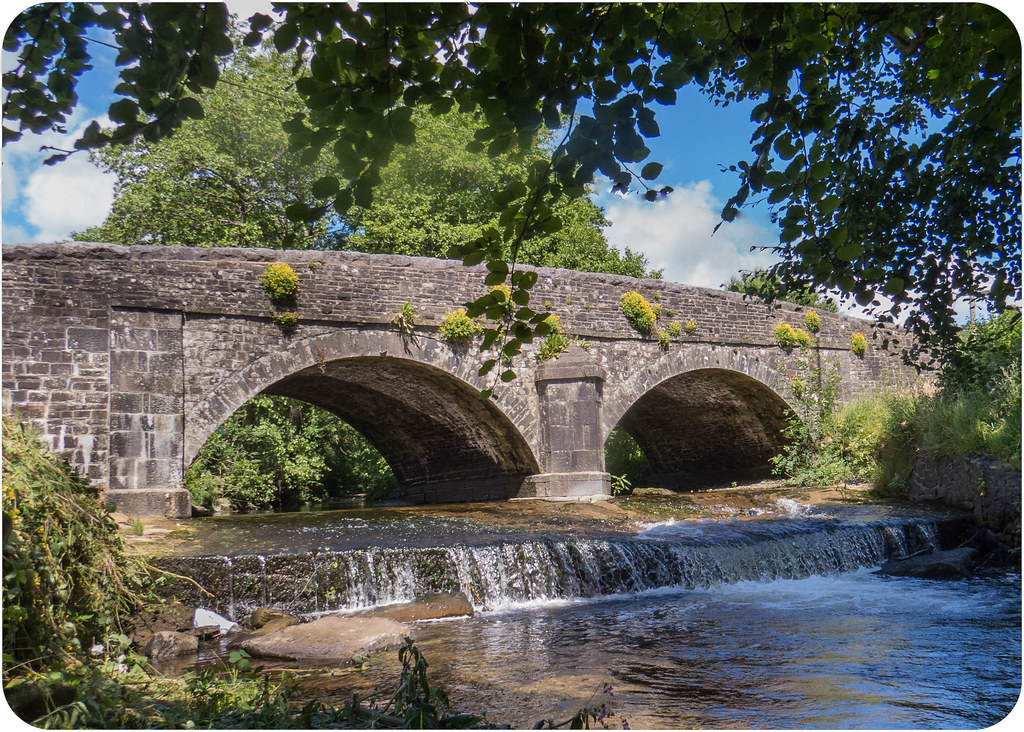
Llandybie bridge across the Marlais.
History
A bridge probably of the mid- or late-C19.

Exterior
A stone bridge with slightly skewed high segmental main span of about 6m. To the east side of the main channel is a small span of about 1.5m wide, similarly constructed, which may be connected functionally with the nearby listed corn mill as a tail-race arch. The bridge is in masonry consisting mostly of axe-squared limestone laid in snecked courses. Much of the masonry including the voussoirs is rock-faced.
Carriageway about 7m wide between parapets about 0.9m high. Flat parapet copings also rock-faced where of limestone; some of the copings are in gritstone. At the south east the parapet has a small return to the river bank.

Reasons for Listing
A C19 bridge of vernacular character in a group with the listed village corn mill and miller's house.

OS Grid: SN619154

Monday 17 April 2017

Dolauhirion Bridge across the Tywi.

One of the most stunning bridges in the county.
              
                    A Grade I listed building: See British Listed Buildings.

                    History
Road bridge across the Tywi, built in 1773 by Thomas Edwards, and one of the outstanding surviving works of the bridge-building Edwards family of Pontypridd. This bridge has the weight-reducing pierced spandrels that Thomas' father the Rev William Edwards introduced at Pontypridd in 1756, one of the very few post-Roman advances in masonry bridge building. This is perhaps one of the most elegant of the surviving Edwards bridges, the very broad elliptical arch rising to a thin crown. Although marked 'Thomas Edward 1773', the bridge was attributed by Thomas Rees writing in 1815 and Samuel Lewis in 1833 to William Edwards, and A Arber-Cooke records that it has also been dated 1785.
                    Exterior
Road bridge, rubble stone single arch of some 25m span and 3.6m width rising high above the Tywi from natural rock abutments. The single broad elliptical arch has large cut stone voussoirs, and the spandrels have masonry in very thin courses and are pierced with large circular holes also with cut stone voussoirs. The abutments are stepped out slightly and splayed. Humped roadway with ramped parapets of rather cruder masonry than the bridge, with stone slab coping stones. In centre of S parapet a slate coping stone marked 'Thomas Edward 1773'.
                    Reason for listing
Included at Grade I as an outstanding example of the revolutionary bridge designs evolved by the Rev. William Edwards and his sons in the later C18.
Scheduled Ancient Monument: CM005

   The following text was extracted from Engineering Timelines:

         The simple and elegant Grade I listed Dolauhirion Bridge is said to be one of the most beautiful  bridges in the world. It carries a minor road (C2157) over the upper River Towy in south Wales and remains in use, with an imposed weight restriction.
         
The first bridge at this spot was recorded in 1396-7 as “'the bridge of Dolhir”, though the present Dolauhirion Bridge dates from 1773 and cost £800 to construct. It was designed by William Edwards (1719-89), the Welsh engineer who built Pontypridd Old Bridge. His sons David (b.1748) and Thomas (1750-1800) were involved too, and Thomas was the contractor.
The single span stone bridge lies 1.6km north of Llandovery and carries a 3.65m wide roadway across the river between rock abutments. Its 25.6m span segmental arch follows an elliptical curve and has deep haunches and a thin crown. One 2.4m diameter cylindrical hole through each spandrel reduces weight on the bridge’s haunches. Edwards first used the technique at Pontypridd in the 1755-6, though it is not unique to him.
In August 1961, The Field magazine claimed Dolauhirion Bridge as the “prettiest” bridge in Britain. A South American magazine later called it one of the 12 most beautiful bridges in the world.

Friday 14 April 2017

Cynghordy Viaduct across the BrĂ¢n .

A Grade II listed building: see British Listed Buildings.

Cynghordy Viaduct.
History
Railway viaduct built for the Central Wales Line by Henry Robertson in 1867-8. A narrow viaduct of 1000' (305m) length and 109' (33m) height, of 18 arches, built on a curve. Henry Robertson, ironmaster and engineer, was the engineer also to the Shrewsbury and Chester line, and the Ruabon to Dolgellau line which included the Vale of Llangollen Railway. He designed the outstanding viaducts at Cefn Mawr and Chirk, both of 1846-8, and the station at Ruabon 1860.
Exterior
Railway viaduct of stone to slightly curving plan. 18 round-headed arches, of great height, yellow brick to arches in 6 bands. Stonework is rock-faced massive rubble, carefully dressed to leave a smooth angle to the piers, which are splayed out at the feet. Below the springing of each arch towards the top of each pier are square projecting blocks, perhaps for erecting wooden scaffolding under arch. Stone flat parapets.
Reasons for Listing
Graded II* as a masonry railway viaduct of outstanding landscape value, notable for the careful detail, the extreme attenuation of the piers and the subtle curve in plan

OS Grid: SN808417

Thursday 13 April 2017

Old Pontamman bridge crossing the Amman river.

A Grade II listed building: see British Listed Buildings.

Old Pontamman bridge crossing the Amman river.

History: Disused road bridge over river Amman, originally later C18 or early C19, doubled in width with new parapets in late C19. There was a bridge at Betws described as a single arch of 13.7metres span, designed about 1775 by William Edwards, but this may have been located downstream at the present location of Betws bridge, shown in a c1847 sketch by J Harwood.

Exterior: Single arch stone bridge, of approx. 18m span, with clear longitudinal break between earlier W part and later E part. The W part has masonry in small coursed stone and unusual arch voussoirs of alternate sizes. The E side has squared rubble masonry with black-ash mortar. Arch has stone voussoirs and keystone. Parapets on both sides have large rock-faced coping stones with tooled arises.

Reason for listing: Listed as a later C18 or early C19 bridge of impressive single span. Sole surviving masonry bridge over river Amman in region, unusually constructed in two longitudinal phases.

Pont-ddu, crossing the Cywyn near St. Clears.

The River Cywyn reaches the River Taf near a farm called "Pilgrim's Rest". The name is appropriate because those following the pilgrim route from Kidelly to St. Clears and then on to St. Davids used to have to ford the river at this point. At times this could be dangerous and on the west side of the river the graveyard of the ruined St. Michael's Church holds a number of what are traditionally known as "Pilgrim's Graves".

Pont-ddu crossing the Cywyn near Pilgrim's Rest.

When the river was too dangerous to cross, a detour had to be made, and as the surrounding area was very marshy, the first viable place was at the spot that Pont-ddu now stands. The obvious connotations of the name "The Black Bridge" hints that even at this point crossing the river could have been hazardous.  The Pilgrim Route is far older than the current bridge but there was probably a structure of sorts at this point for centuries.

Bridge over the river Cothi at Edwinsford.

A Grade II listed building: see British Listed Buildings.

Bridge over the Cothi at Edwinsford, built in 1783 by David Edwards.
History:
Built for Robert Banks Hodgkinson who married Bridget, daughter and heir to Thomas Williams of Edwinsford in 1783. The designer was David Edwards, son of the celebrated bridge-builder William Edwards of Beaupre Cowbridge. David Edwards built several bridges in S Wales, a local example being that at Llandeilo-yr-ynys.

Exterior: 1783 bridge by David Edwards. Datestone to centre of inside E parapet wall: " This Bridge is the property of the family of Edwinsford. Rebuilt by Robert Banks Hodgkinson Esq. 1783 ". Wide single-span bridge of stone laid in fine diminuishing courses. Broad elliptical arch, dressed stone voussoirs. Low parapet walls rising to a central point.

Reason for listing: Attractive late C18 bridge of impressive span by an important Welsh bridge architect.


No longer a road bridge, the centre is now grassed over.


Jervoise (1936) states: Pont Pwll-du over the Cothi at Edwinsford, is now a lattice girder bridge, which must have replaced the one built by David Edwards.
 Presumably Jervoise was unaware that the bridge still existed a matter of 100 yards round the corner from what used to be the lattice girder bridge he mentions.

OS Grid: SN631346

Bridge over the river Sawdde, at Three Horseshoes near Llangadog.

 A picturesque setting where migrating fish like salmon and birds typical of rocky streams such as dipper and grey wagtail can be readily observed from the bridge.

Ordnance Survey grid reference SN728245.

Wednesday 12 April 2017

Lampeter Bridge across the Teifi.

Lampeter Bridge(Pont Stephan, Llanbedr).
Lampeter Bridge - This is over the Teify on the main road from Lampeter to Llandovery and within half a mile of the former. It is built of stone and comprises three arches, two of them with a span of 25 feet and a central arch of 35 feet span, besides a land arch on the Carmarthenshire side of 22 ft span. It was erected in 1830 at the joint expense of the counties of Carmarthenshire and Cardigan, and the parish of Pencarreg. The contract was for £520, of which Cardiganshire paid £150, Carmarthenshire £200 and Pencarreg £170.
Arthur Mee, Carmarthenshire Notes.

Ogilvy showed a stone bridge with three arches at "Lanbedar, pont Steffan", the old name for Lampeter, and also a "Wood Bridge and Brook" a short distance to the south-east. The present one however, which was reconstructed in 1932, only dates from the year 1827.
Jervoise (1936).

Site Description Four arches over River Teifi. 35 ft. span, 21 ft. span and 2 x 27 ft. span arches. Partly in Carmarthenshire.

Grid Reference SN5810447617

Tuesday 11 April 2017

Bridge crossing the river Tywi at Llangadog.

Tywi Bridge, near Llangadog.

Site Description A fine five arched bridge carrying what was once the main route into south Wales. The bridge was rebuilt by act of Parliament in 1818-19.

The river is spanned by three broad segmental arches of which the centre arch is the widest. Two smaller, but otherwise similar arches cross the floodplain to the east. The arches all have fine stone voussoirs or arch stones, and are divided by triangular stepped cutwaters. Raised bands run below the parapets, which are thought to have been rebuilt later in the nineteenth century.

Source: CADW Listed Buildings Database (10947/21995)
Grid Reference SN6951928619

Monday 10 April 2017

Llanfallteg Bridge crossing the River Taf.

A Grade II listed building. See British Listed Buildings

The bridge crosses the River Taf between the villages of Llanfallteg and Llanfallteg West. The length of the supporting wall testifying to the extent of the floodplain at this point.

Llanfallteg Bridge crossing the floodplain of the River Taf.

History: Probably late C18 or early C19 and, with its pierced spandrels, typical of SW Wales bridges of the period.
Exterior: A single-span double-carriageway bridge of coursed rubble. A segmental arch has cut voussoirs, with similar detail to pierced roundels in the spandrels. The coped parapet is splayed out on the SW side. On the NE side is a long causeway of stepped rubble stone, partly rebuilt, incorporating a single segmental flood arch.
Reasons for Listing: Listed as a well-preserved road bridge in a vernacular style characteristic of the region.

OS Grid: SN151194

Sunday 9 April 2017

Pont Cothi at Abergorlech.

 The River Cothi is a tributary of the Tywi, which it joins just before Nantgaredig Bridge.

Pont Cothi spanning the river at Abergorlech.

Spanning the Afon Cothi in the centre of Abergorlech, on the border between Llanfynydd and Llanfihangel Rhos y Corn communities.

A grade 2 listed building. More info.

The ancient bridge has two arches and two prominent ‘cut-waters’ either side of the bridge surface, which provided passing places for those crossing the bridge as well as giving strength to the structure. The bridge is at least of 16th century date and may be late medieval. A carved stone records its repair by John Jones in 1794.

The Bridge over the River Bran in Llangadog.


The Bridge over the River Bran in Llangadog.
  
History
Road bridge over the River Bran, probably early C19, built before 1833. The treatment of the cutwaters is very similar to that on Pont ar Towy (q.v.) of 1819, said to have been designed by William Harries.


Llangadog Bridge with St. Cadogs Church in the background.
Exterior
Bridge, rubble stone, three-arch with cut grey stone voussoirs, small stones in spandrels and triangular cutwaters with stepped triangular tops. Centre arch is broad, outer arches narrow. Plain parapets with stone copings, raised piers each end.


Reasons for listing
Included as an architecturally-designed three-arch stone road bridge, of unusual quality.

A Grade 2 listed building.  More info

Thursday 6 April 2017

Llandeilo-yr-yns Bridge crossing the river Tywi at Nantgaredig.

Llandeilo yr ynys bridge crossing the Tywi at Nantgaredig.
History: A less-known bridge designed by the Rev William Edwards of Eglwysilan (1719-89), the designer of Pontypridd bridge (1755) and other important South Wales bridges, or by his son David. It was built for the Llandilo Rwnws Bridge Trust established in 1784, the purpose of which was to exploit the Llanddarog lime and limestone traffic which had previously crossed the Towy by a ford at this location. It was completed in 1787 at a cost of £1200.

This was a bridge at which the charging of extortionate tolls was a factor in the Rebecca Riots. The gate was at the southern approach, the tollhouse on the west side. The tolls were later rented from John Jones, of Ystrad (Capel Dewi) by the trustees of the Three Commotts Turnpike Trust, to whom the ownership was eventually transferred in the early C19. After the turnpikes reorganisation of 1845 the bridge was operated by the County Roads Board. It was restored in 1931 after serious flood damage and also in 1933.

A photo showing the flood damage in 1933.
Exterior: A fine limestone bridge of three equal 15m spans, in randomly coursed masonry. The carriageway is about 3.6m wide between parapets. The arches are semicircular, formed with deep narrow ashlar voussoirs; there are no keystones. The cutwater buttresses between the arches both upstream and downstream are carried up to form pedestrian refuges. The parapets have large flat rock-faced copings. At each end they fan out slightly.

Reason for listing: Listed as a fine late-C18 bridge by an important architect/builder with special social historical interest in connection with the Rebecca Riots.

Also known as Pont Llandeilo'r-ynys, Rhynnws Bridge, Pont-newydd or Newbridge.

Wednesday 5 April 2017

Cilsan Bridge over the Tywi near Llandeilo.

Cilsan Bridge over the Tywi near Llandeilo.
History:  The bridge was built near the site of the former Cilsan Ferry. It is believed that The Three Commons Turnpike Trust (dissolved 1845) had planned a bridge in this location, and there are references to a bridge here by the 1850s: in June 1850, the published 'Diary of Thomas Jenkins'has an entry as follows: 'took Miss Davies over Cilsan Bridge in phaeton', and R.K. Penson's 'Carmarthenshire Bridges 1854, sketches' notes a bill for bridge repairs at Cilsan. The 1839 Tithe map shows a newly built approach road (but no bridge) suggesting perhaps a bridge was built here c.1840-45.

A fine stone bridge of three equal spans. High arches, designed to cope with the notorious flooding of the Towy.

Exterior :   Squared limestone common masonry in small courses; dressings in ashlar: arches, cutwaters, parapets. The arches are semi-elliptical, with spans of about 18m. Cutwaters with a small offset at mid height, sloping top, countinued up to parapet level as shallow pilasters. The carriageway is wide, with low parapets each side. Grey limestone copings. At the approaches the carriageway is wider and the parapets are in a rougher masonry.

Reasons for listing :  An elegant mid-Victorian main-road bridge in local masonry.

Tuesday 4 April 2017

Pont Pentre Felin crossing the River Myddyfi.

Pont Pentre Felin crossing the River Myddyfi
Pont Pentre Felin over a rocky stretch of the river Myddyfi, near Llandeilo (at Ordnance Survey grid reference SN597237).

The River Myddyfi is a tributary of the Tywi, joining it near to Cilsan Bridge.

Monday 3 April 2017

Stone bridge in the village of Llansawel


An attractive bridge with two arches over the Afon Marlais at LLansawel with yellow corydalis growing out of the stonework.

Thursday 30 March 2017

Bridge across the River Taf at St. Clears.

Bridge over the River Taf at St. Clears.


St. Clears Bridge is on the community boundary of Llanddowror and St. Clears.
 It is a Grade II listed building because it is a broad-span single arch bridge with distinctive spandrel holes, built in the manner of the pioneering design by William Edwards at Pontypridd in the 18th century

Glangwili Bridge over the Gwili, near Carmarthen.

Glangwili Bridge over the River Gwili near Carmarthen.
The following id from the British Listed Buildings website:

History

Earlier C19 road bridge over the Gwili river on the Carmarthen to Lampeter turnpike road. On 3/6/1809 the Carmarthen and Lampeter Trust (founded 1788) obtained an act renewing existing acts, which may be connected with the improvement of the road. The bridge is now disused, by-passed by modern A 485 bridge adjoining. The pierced spandrel holes are derived from the bridges of the Edwards family, first used by the Rev. W. Edwards at Pontypridd in the mid C18.

Exterior

Road bridge over the Afon Gwili. Rubble stone broad shallow arch with cut stone voussoirs. Pierced small circular opening through each spandrel with cut stone voussoirs around. Raised string course under parapet ramped up to centre with grey limestone coping. Double raised pier on each abutment framing a large circular flood arch with stone voussoirs. Pyramid coping stones to parapet above each pier.

Reasons for Listing

Included as a fine single-span stone road bridge.

Wednesday 29 March 2017

Trevaughan Bridge crossing the Taf at Whitland.

Trevaughan Bridge crossing the river Taf at Whitland.

The plaque on the bridge is said to have been dated "1767". he bridge was widened on the north side in 1856 and on the south side in 1878. Both extensions were in keeping with the original work. The bridge, close to the south-west corner of St Mary's (NPRN 105014) churchyard, was replaced by the present road bridge after 1981, when the B4328 was diverted to some 30m further west. The section of former B4328 is now a no-through-road, terminating immediately after the Trevaughan Bridge, on its west side. Its western embanked approach was removed to prevent flooding, giving the bridge a curiously unbalanced aspect.

The bridge is a grade II listed building. It has three segmental arches separated by cut-waters. The centre arch is rather wider and flatter. The bridge is built of stone rubble with cut stone vousoirs to the arches. The original arches are visible from below and these have similar cut stone vousoirs.

Tuesday 28 March 2017

Rhandirmwyn Bridge

Rhandirmwyn Bridge is the first major bridge across the Tywi and lies just a couple of miles from Llyn Brianne.

Rhandirmwyn Bridge across the Tywi.
According to a plaque attached to the bridge, it was built by Rees & Kirby of Morriston  in 1913.

Friday 24 March 2017

Llandeilo Bridge crossing the Tywi.


Llandeilo Bridge carries the A483 northwards from Ffairfach to Llandeilo, Llandovery and beyond. It  was designed by William Williams in 1840 and completed by Edward Haycock in 1851, and at one time had one of the largest spans in Britain. It replaced an earlier bridge that was heavily damaged by floodwaters, depicted by JMW Turner in his landscape painting of 1795, and by MA Rooker a year later.

Llandeilo Bridge across the Tywi river.

An excellent account of the history of Llandeilo Bridges is given here.

More information on Llandeilo Bridge from the Engineering Times 

LLandeilo Bridge by JMW Turner in 1795 and by MA Rooker in the following year.

Tuesday 21 March 2017

Pont Rhyd Felin over the Nant Melyn.

There is a wonderful country road that leads from Pumpsaint, through Cwrt-y-cadno and eventually on to Cilycwm. It follows the course of the river up the Cothi valley high into a mountain wilderness, before crossing over to come down into the Tywi valley, joining the river Tywi just below Llyn Brianne.

Pont Rhyd Felin.
 A highlight on this journey is Pont Rhyd Felin. When driving across it seems like an ordinary sort of bridge, but if you take the time to stop and look around, you'll find it is one of the prettiest bridges in the whole of Carmarthenshire. A small stream, Nant Melyn, cascades down the mountainside, creating waterfalls on either side of the arch, before continuing its journey down a rocky wooded valley to join forces with the Gwenffrwd and a short distance later, the mighty Tywi itself.

Wales' only Bascule Bridge, across the Tywi at Carmarthen.

A Bascule bridge is a moveable bridge with a counterweight that continuously balances a span, or "leaf", throughout its upward swing to provide clearance for boat traffic. Once a fairly common feature, with the demise of high-masted ships the need for bascule bridges diminished and now there are only twenty remaining in the UK, the most famous being Tower Bridge in London.

Wales' only Bascule Bridge, across the Tywi at Carmarthen.

In Wales there is now only one remaining - it carries the Paddington to Fishguard railway across the river Tywi at Carmarthen. Also known as The White Bridge, it was built in 1903 and came down for the last time in 1956.

Although it can clearly be seen from the road bridge that carries the A40 across the Tywi, to allow you to get a closer look there is now a cycle way come pathway that will take you right up to it and from here you can really appreciate its grandeur as well as get an idea of the engineering that made it all work.

Monday 20 March 2017

Newcastle Emlyn Bridge over the Teifi.

Newcastle Emlyn Bridge over the Teifi.
Jervoise (1936), says of this bridge:  The bridge at Newcastle Emlyn has a span of 40 yards, and now has a roadway of 19 feet in width. Its three arches are segmental in form and have been widened on the downstream side by 7 feet. There are massive cut-waters on the upstream side, but the recesses have been filled up to strengthen the parapet. In the time of Rowlandson (1797) the parapets were extremely low.

Newcastle Emlyn Bridge, Rowlandson (1797).


 This print showing the bridge in 1797 was drawn by the celebrated cartoonist Thomas Rowlandson (1756-1827) and is held at the National Library of Wales.

Friday 17 March 2017

Kidwelly Bridge over the Gwendraeth Fach

Kidwelly Bridge over the Gwendraeth Fach.
Jervoise (1936) states that: The bridge that crosses the Gwendraeth Fach at Kidwelly is now nearly 30 feet in width, but contains part of an ancient structure. . . . it is difficult to see the ancient part of the bridge except at river level.  C.A.R. Radford, in his paper on Kidwelly Castle read before the Socity of Antiquities in April 1933, suggested that the structure dated from the end of the 15th century. . . . Henry Gastineau, in Wales Illustrated, showed a bridge with one pointed and one semicircular arch.

Monday 6 March 2017

Spudder's Bridge over the Gwendraeth Fawr

Spudder's Bridge over the Gwendraeth Fawr.
Jervoise (1936) states:  Pont Spwdwr, the only bridge of note over the Gwendraeth Fawr, is undoubtedly the stone bridge recorder by Lambarde, and towards which David Vaughan of Trimsaran left in his will, which was proved in 1571, the sum of 40s. . . . Ogilby's route from London to St. Davids crossed by this bridge, which he called "Pont Spuddore".

Pont Spwdwr has six pointed arches, three large and three small, but in normal times the whole river passes under one arch.  The total span is 71 yards, and the width between the parapets is 9feet, but there are four cut-waters, with recesses on each side. It is by far the most ancient bridge in South Wales.

More information on Spudder's Bridge from the Engineering Times.

Sunday 5 March 2017

Cenarth Bridge over the Teifi

Cenarth Bridge over the Teifi.
A bridge over the River Teifi at Cenarth has existed at least since 1188, when it was mentioned in the writings of Gerald of Wales. The present bridge was constructed between 1785 and 1787 by Messrs Watkins and Webb. It was designed by David Edwards (born 1748), who also built the Llandeilo Yr Ynys bridge near Nantgaredig earlier in 1786. The bridge was widened in 1852. More info.


An 1839 depiction of the bridge by Henry Gastineau in the Wales Illustrated magazine  is shown here.


Cenarth Mill alongside the bridge is probably one of the most photographed mills in Wales. It has a history going back to Edward I. The current building is 17th century and today houses the National Coracle centre.
More info. 

More info on Cenarth Bridge from the Engineering Times.

Thursday 2 March 2017

A girder Bridge over the river Doethie near Rhandirmwyn.

Girder Bridge across the river Doethie.


Set in the wilds above Rhandirmwyn, the river Doethie is the first tributary to join the river Tywi, giving this girder bridge across the Doethie beneath Craig Clungwyn, the title of being Carmarthenshire's most northerly bridge and another crossing point between Carmarthenshire and Ceredigion.

Wednesday 1 March 2017

Pwllpriddog Bridge across the Tywi.

Click here for an image of the old Pwllpriddog Bridge, which was built in 1927 and demolished in 1995 to make way for the new bridge.

Pwllpriddog Bridge.

Wednesday 4 January 2017

Gallt-y-bere Bridge, the first bridge to cross the River Tywi.

Gallt-y-bere is the first bridge across the river Tywi after it tumbles down from Llyn Brianne.  Originally there was a footbridge across the Tywi which was shown on the Ordnance Survey map of 1903. This was later replaced by a "Ferro-concrete cart bridge", constructed in 1928 by a George Palmer of Neath, after the footbridge was washed away in a flood in 1926. There is a nice collection of old photos of the various Gallt-y-bere bridges on a Rhandirmwyn website. Click here.

Also an article about Gallt-y-bere on the Cilycwm website. Click here.

The new Gallt-y-bere bridge across the Tywi.
In 2014, George Palmer's bridge was demolished and replaced by this new bridge, constructed by TRJ (Ammanford) at a cost of £1 million. More info.